


Pipelines face rising risks from heat stress, floods, frost, landslides, and subsidence.
Standards like ASME B31.8S, API 1160, CSA Z662, PHMSA guide response.
Use ILI, fiber optics, InSAR, digital twins to monitor.
Mitigate with smart design, protective systems, emergency plans.
Track KPIs: time-to-detect, exposure rate, MTBF, cost–risk ratio.
Introduction — Why Climate & Geohazards Matter
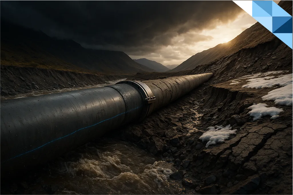
Pipelines cross deserts, floodplains, permafrost, and mountain corridors. As climate variability intensifies, temperature extremes, hydraulic events, and ground movements are now primary external threats to pipeline integrity—not peripheral ones.
For integrity and HSE leaders, the mandate is clear: integrate climate and geohazard risk into a practical Integrity Management (IM) program that balances safety, reliability, and cost. This article clarifies major threats, maps them to recognized standards, shows fit-for-purpose monitoring, and translates them into mitigation playbooks and KPIs you can track.
New to the fundamentals? See: What is Pipeline Integrity and What is Pipeline Inspection.
Key Environmental & Geohazard Threats
Thermal Stress & Temperature Variations
What happens: Thermal expansion/contraction increases axial stress, accelerates fatigue, and can trigger global buckling in above-ground lines or coating disbondment on buried lines. Wider diurnal swings and heatwaves/cold snaps magnify these effects.
Signals & indicators
- Elevated strain readings on long straight runs
- Recurring buckle alarms or localized upheaval
- Coating holidays correlated with heat cycles
Mitigation snapshot
- Design for expansion (loops, offsets, sliding supports), verify anchorage
- Optimize operating envelopes (pressure cycling) during extremes
- Prioritize ILI for ovalities/dents and strain-based assessment
Flooding & Scour
What happens: High flows remove cover (washouts), expose spans, and increase hydrodynamic forces. Riverbed scour undermines support, creating free spans prone to bending and vortex-induced vibration.
Signals & indicators
- Sudden cover loss after storms
- Span growth on river/creek crossings
- Fiber optic or acoustic alerts during peak discharge
Mitigation snapshot
- Riverbed stabilization, rock armoring, and concrete weight coating
- Reroute or deeper burial in chronic scour zones
- Seasonal operational controls (pressure/flow limits during floods)
Frost Heave & Permafrost Thaw
What happens: Freezing expands pore water (upward heave). Thaw weakens soils, causing differential settlement and misalignment. Freeze–thaw cycling stresses girth welds and supports.
Signals & indicators
- Progressive vertical deflection and support distress
- Elevated CP current demand in wet, thawing soils
- InSAR (Interferometric Synthetic Aperture Radar) trends showing seasonal vertical movement
Mitigation snapshot
- Thermal insulation, heavy cushions, adjustable supports
- Design for settlement tolerance; reroute where feasible
- Real-time ground temperature monitoring; seasonal O&M windows
Landslides, Earthquakes & Subsidence
What happens: Slope failures impose large longitudinal strains; seismic events introduce sudden displacement; subsidence (natural or anthropogenic) creates long-wave bending.
Signals & indicators
- Slope cracking, tilting poles, scarps, groundwater spikes
- Seismic shake detection with aftershock deformation
- Regional InSAR showing bowl-shaped settlement
Mitigation snapshot
- Geotechnical stabilization (drainage, buttressing, soil nails)
- Flexible design (expansion joints, slack loops) in active zones
- Shut-in criteria linked to seismic/landslide thresholds
Study of Fault Lines and Seismic/Landslide Risks in Pipeline Routes
What happens: Active fault lines, seismic events, and slope instabilities introduce combined geohazard stresses that can severely compromise pipeline reliability. Beyond generic “landslide/earthquake” categories, a structured study of fault lines and seismic/landslide risks is critical.
Key considerations:
- Fault line mapping & monitoring: Identify and track active geological faults along pipeline corridors, using geophysical surveys and satellite data.
- Seismic hazard assessment: Evaluate ground shaking, liquefaction, and permanent ground deformation that can impose axial and bending strains.
- Landslide risk analysis: Assess slope stability in hilly/unstable terrain where soil mass movement can buckle or rupture buried pipelines.
- Impact modeling: Quantify stresses, strains, and failure modes (buckling, rupture, loss of containment) under modeled geohazard events.
- Integration into IM systems: Feed results into risk models and integrity management programs, ensuring compliance with international codes like API RP 1160 and ASME B31.8.
Mitigation snapshot:
Route optimization to avoid high-risk corridors, seismic-resistant design features (strain-tolerant welds, expansion loops), slope stabilization (soil nails, drainage), and continuous monitoring (InSAR, fiber optics) to detect precursors.
Why it matters: Embedding geohazard studies in IM programs minimizes risk to people, the environment, and infrastructure—delivering both regulatory compliance and resilience.
Regulatory & Industry Frameworks
Aligning with recognized frameworks strengthens governance and accelerates approvals.
- ASME B31.8S (Gas Transmission): Treats natural force damage (e.g., landslides, floods, extreme weather) as core threats; requires risk-based assessment, data integration, and proportional preventive/mitigative measures.
- API RP 1160 (Hazardous Liquids): Embeds external loads & geohazards into risk models; calls for flood mapping, soil mechanics, and emergency preparedness.
- CSA Z662 Annex O (Canada): A practical, stepwise geohazard framework: identification, characterization, ranking, monitoring, and mitigation with strong documentation discipline.
- PHMSA Advisories (U.S.): Emphasize flooding, scour, soil movement evaluation within IM programs; encourage climate-aware preventive/mitigative planning and post-event assessments.
Want a deeper contrast between assessment and management? See:
• Pipeline Integrity Assessment vs Management
• Pipeline Integrity Assessment Guide
• RBI vs TBI in Pipeline Management
Monitoring & Technology Solutions
A resilient program blends periodic inspection with continuous sensing and predictive analytics.
Inline Inspection (ILI)
Use for: Metal loss, deformation, and crack detection; infer strain accumulation from geohazards.
Why it matters: Converts hidden threats into actionable anomaly lists with location accuracy.
ECDA & DA Extensions
External Corrosion Direct Assessment (ECDA) and broader Direct Assessment (DA) integrate site walkdowns, soil studies, and slope inspections—vital where ILI is constrained (e.g., riverbanks, stations).
Fiber Optics (DAS/DTS/Distributed Strain)
Detects: Micro-strain, vibration, temperature anomalies along the ROW.
Value: Real-time signatures of ground movement, third-party interference, or leak-induced cooling.
Satellite InSAR
Detects: Millimeter-scale surface motion over large corridors.
Value: Regional subsidence/landslide baselines, trend maps to prioritize field checks.
Acoustic Monitoring
Detects: Leak acoustics, soil movement, hydraulic impacts during floods.
Value: Early warning to trigger patrols or pressure reductions.
Data Integration & Digital Twins
What it is: A live, virtual replica of the pipeline, fed by ILI, sensors, weather, hydrology, geotech data.
Why it matters: Enables predictive what-if analysis, risk visualization, and decision support.
Practical Mitigation & Management Strategies
Goal: Convert monitoring into risk reduction with the best ROI.
Design-Level Interventions
- Routing & avoidance: Skirt unstable slopes, floodways, permafrost where practicable.
- Burial & supports: Increase cover, add engineered supports or weighting where scour and uplift prevail.
- Materials & joints: Use higher-toughness steels, strain-tolerant welds, and flexible joints in movement corridors.
- Crossings: Design for free-span limits, vortex shedding control, and armoring.
Operational Controls
- Seasonal playbooks: Pre-flood pressure reductions, flow throttling, or temporary shutdowns.
- Weather gating: Tie O&M and excavations to forecast windows.
- Event protocols: Post-event patrols, elevated surveillance, and rapid assessment after exceedances.
Protective Measures
- Cathodic Protection (CP): Re-baseline CP in wet/thaw cycles; monitor current demand shifts.
- Advanced coatings: FBE, 3LPE/3LPP, abrasion-resistant overlays in high-energy soils.
- Stabilization: Rock armoring, geotextiles, soil nails, and drainage to manage pore pressures.
Emergency Response & Contingency
- Trigger matrices: Clear shut-in and pressure-reduction criteria for flood stages or slope movement rates.
- Pre-staged kits: Spares, clamps, weights, and access logistics in known hotspots.
- Exercises: Scenario-based drills (e.g., river exposure, landslide rupture).
Looking for a holistic service partner? Explore: Asset Integrity Management
KPIs for Measuring Effectiveness
Use KPIs that capture speed, exposure, reliability, and economics:
- Time to Detect (TTD): Event → first credible detection.
- Time to Respond (TTR): Detection → mitigative action (e.g., pressure change, dispatch).
- Exposure Rate (%): Share of kilometer-segments in geohazard zones (floodplain, active slopes).
- Failure Frequency: Geohazard-related incidents / 1,000 km / year.
- MTBF (Mean Time Between Failures): Higher is better; track by region/threat.
- Mitigation ROI / Cost–Risk Ratio: ∗∗ΔRisk∗∗(avoidedconsequence)/∗∗ΔCost∗∗**Δ Risk** (avoided consequence) / **Δ Cost**∗∗ΔRisk∗∗(avoidedconsequence)/∗∗ΔCost∗∗ to justify fiber optics, armoring, etc.
Tip: Pair KPIs with thresholds (e.g., TTD < 2h in flood corridors) and review cadences (monthly ops, quarterly governance).
Conclusion — Actionable Recommendations for Asset Managers
- Make geohazards first-class threats in your IM plan—budget and report on them explicitly.
- Map exposure with data fusion: Combine InSAR + fiber optics + ILI + flood maps into one risk picture.
- Pre-wire seasonal playbooks: Link pressure/flow policies to forecast triggers.
- Engineer flexibility where the ground moves: Supports, anchors, joints, slack, and free-span control.
- Stabilize the terrain, not just the pipe: Drainage, armoring, soil reinforcement where root-cause is geotechnical.
- Test readiness: Drill landslide/flood scenarios; measure TTD/TTR.
- Align to standards, document decisions: ASME B31.8S, API 1160, CSA Z662 Annex O, PHMSA.
- Optimize with KPIs: Fund what best reduces exposure and failure frequency per dollar.
FAQ — Climate & Geohazards in Pipeline IM
1) What are the top climate/geohazard threats to pipelines?
Thermal stress, flooding & scour, frost heave/permafrost thaw, and landslides/earthquakes/subsidence.
2) Which standards should I anchor to?
ASME B31.8S, API RP 1160, CSA Z662 Annex O, plus PHMSA advisories and local regulators.
3) How do I monitor large corridors effectively?
Blend ILI/DA locally with fiber optics and satellite InSAR for regional coverage; integrate into a digital twin.
4) What low-capex mitigations deliver quick wins?
Operational controls, CP tuning, selective armoring, and weather-gated O&M targeted by risk maps.
5) How do KPIs help?
They show speed (TTD/TTR), exposure (% in hazard zones), reliability (MTBF), and value (cost–risk) to prioritize funding.
6) Where do assessment and management differ?
Assessment finds and ranks threats; management embeds mitigation, monitoring, and governance.
7) Should I use RBI or TBI for geohazards?
Contextual. RBI prioritizes by likelihood × consequence using live data; TBI enforces interval discipline.
Work With NWE Group
Build a resilient, standards-aligned program that turns climate and geohazard exposure into measurable risk reduction.
→ Explore Asset Integrity Management and related guides:

3 Responses
Very timely read – climate risks are becoming the biggest challenge in integrity planning
Clear examples of geohazards, will share this with my HSE team
Great to see practical strategies, not just theory. Well done